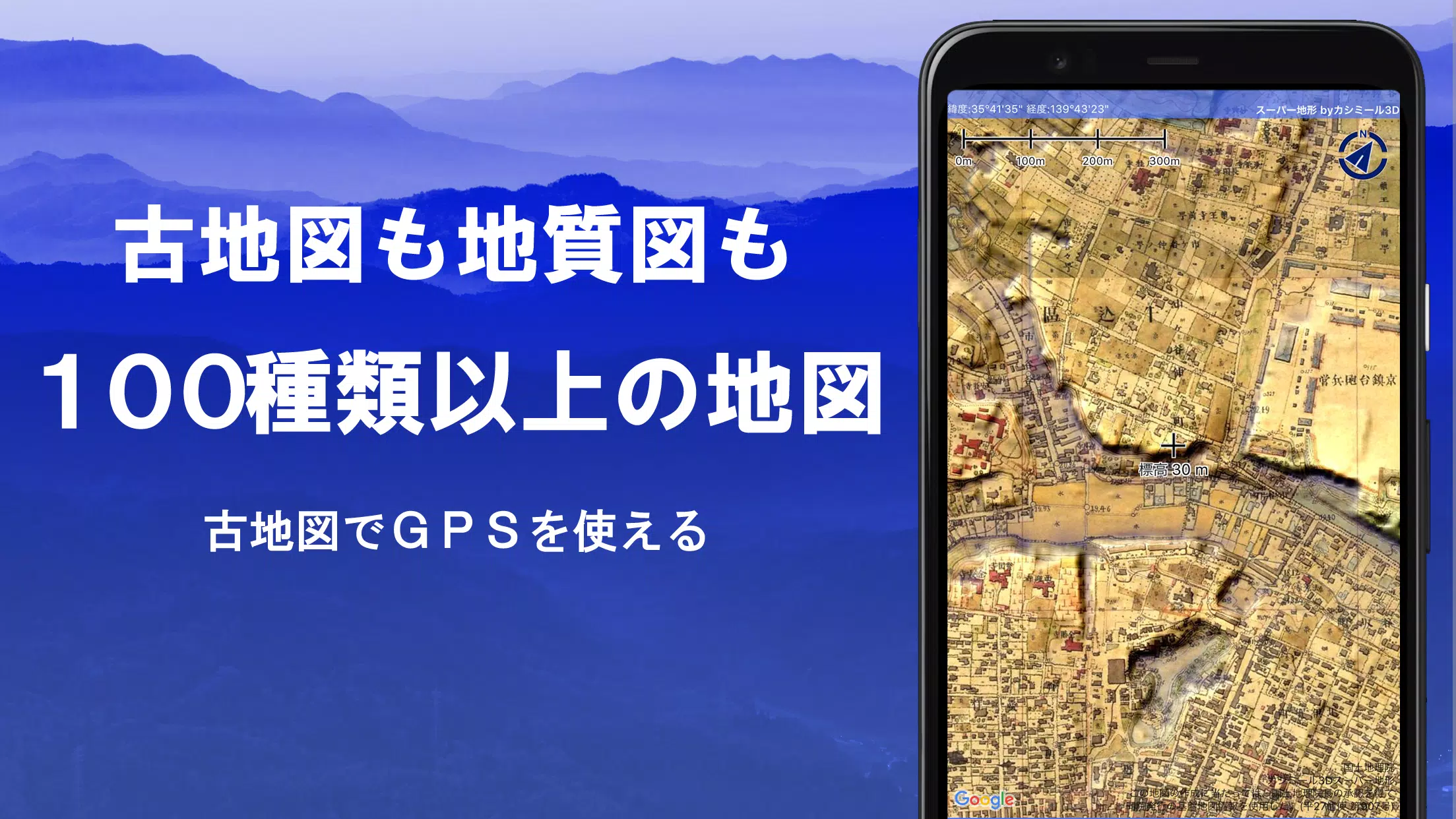
Discover over 100 types of maps, including the acclaimed Geographical Survey Institute map, perfect for enhancing your experiences from mountain climbing to urban strolls. This versatile application was honored with the 2018 Japan Cartographic Society Award for Best Work, showcasing its excellence in the field of cartography.
Leverage "super terrain data" that brings terrain to life through cutting-edge technology. Access an extensive range of maps from the Geospatial Information Authority of Japan, including topographic, geological, historical, and prewar Ordnance Survey maps. With GPS functionality, you can record your tracks (trajectories), and utilize GPX log input/output and editing capabilities to tailor your adventures.
The app is equipped with comprehensive features to support urban exploration, mountain climbing, and outdoor activities, including GPS navigation with audio support, and data recording and editing. Utilize the visibility determination function for creating cross-sectional diagrams, observing landscapes, and optimizing radio communication. Buildings can also be visualized for a more detailed view.
Experience the immersive 360° panoramic view function, which includes mountain identification capabilities, allowing you to identify mountains by name. You can also view celestial bodies such as the sun and moon, along with GPS points. The app's robust GPS features, bulk map downloads, and map cache ensure a seamless offline experience, ideal for remote mountain climbing or outdoor ventures.
Enhance your maps by associating photos with specific points, displaying contour lines generated from elevation data, and showing the MGRS grid (UTM grid). You can read, display, and edit GIS data from GeoJSON files, draw shapes, and use the app overseas. Additionally, map printing and PDF output are supported, and the app features a user-friendly dark theme.
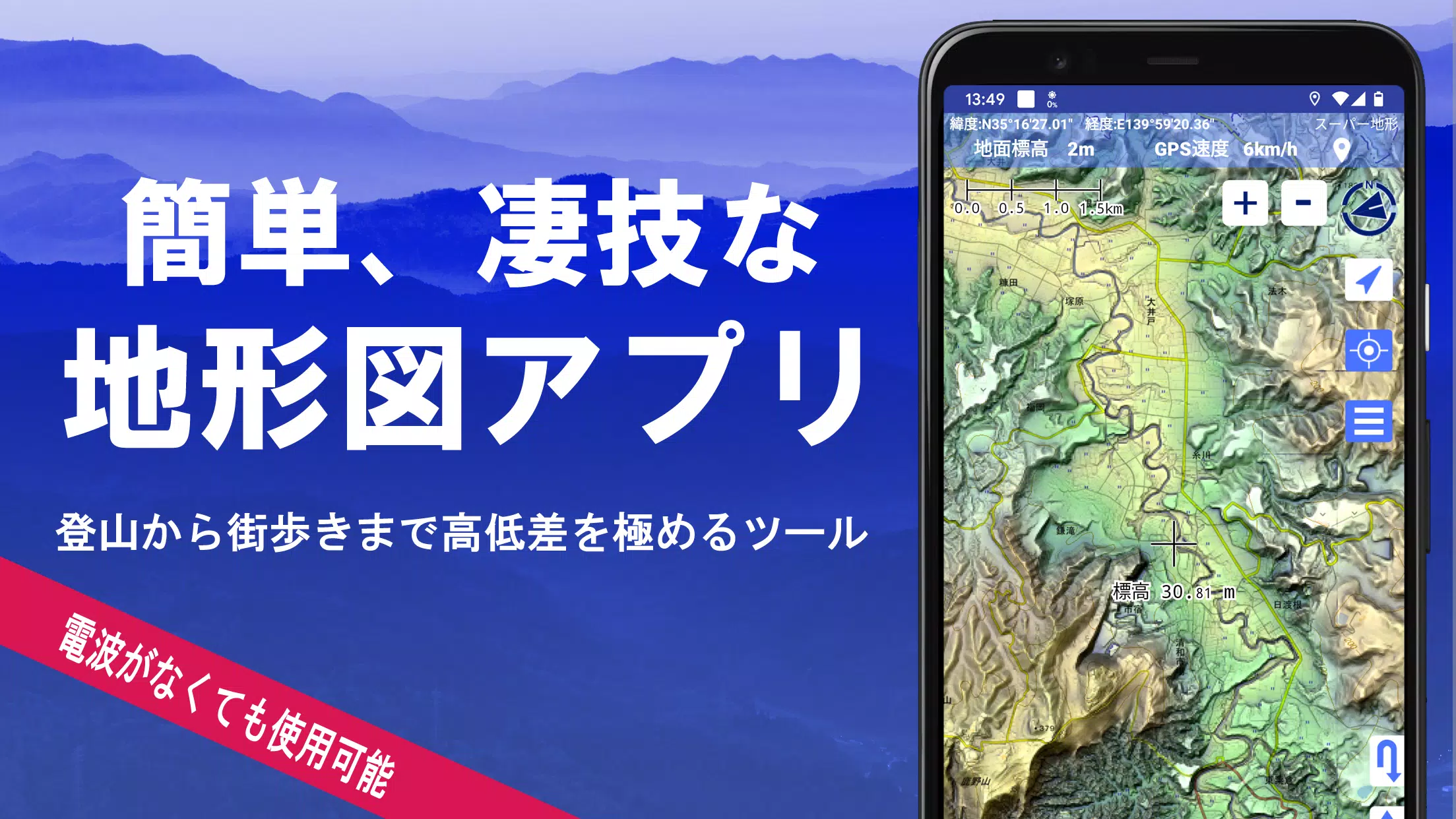
1. A Wealth of Maps at Your Fingertips
Explore over 100 types of maps, including our proprietary super topographic data and maps from the Geospatial Information Authority of Japan. Aerial photographs are categorized by age, with coverage varying; the "latest" and "around 1974" categories offer extensive coverage. Enjoy a 5-day free trial of maps using super terrain data upon installing the app.
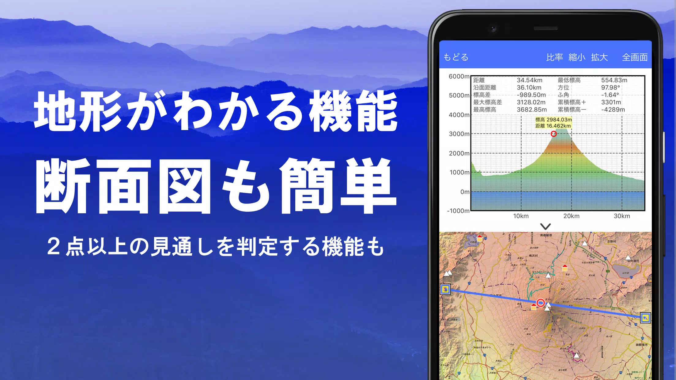
2. Cross-Section and Outlook Creation
Effortlessly draw cross-sections through any point on the map. Utilize the renowned visibility judgment function from Kashmir 3D, which accounts for Earth's curvature and atmospheric conditions, ideal for route planning, wireless visibility checks, and terrain analysis. Where PLATEAU building data is available, you can include buildings in your cross-sectional views.
3. Elevation Palette Function
Customize your map's appearance with the elevation palette function, which allows you to change the background color in 1cm increments, creating personalized gradients.
4. Panoramic View
Access panoramic observation maps to identify mountains by name from any location. The 360° panorama integrates with your smartphone's compass for accurate mountain identification. You can also view the sun, moon (including phases), and GPS points, perfect for capturing Diamond Fuji and Pearl Fuji. This feature extends to overseas mountain panoramas as well.
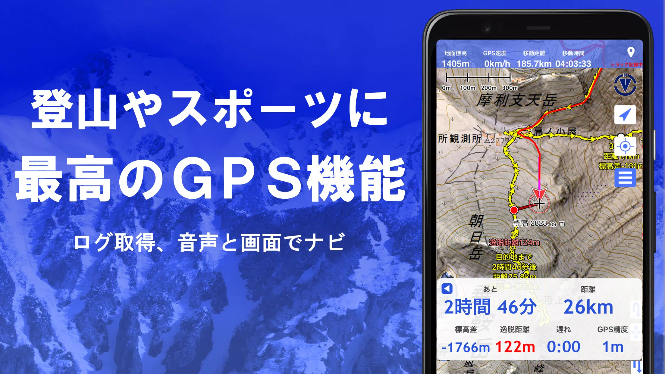
5. GPS Functionality
Harness your smartphone's GPS to obtain precise location data and record tracks. The app offers high-precision positioning suitable for serious mountain climbing and outdoor activities. Display recorded tracks with parameters like elevation gain, speed, time, and elapsed time. The point alarm function alerts you with voice and sound as you near designated points. You can also display photos linked to specific points and send the map center position to NaviCon.
6. GPS Track Summary Playback
Replay your tracks in full with the GPS track summary playback feature. The app automatically matches and displays photos from your smartphone based on their capture times, with icons marking photo locations for easy access.
7. GPS Navigation Function
Navigate along preset tracks using the Track Navi function, which alerts you with voice or sound if you deviate from the path, ensuring you never lose your way during climbs. The app also supports route navigation for urban walks and point navigation for targeting specific locations.
8. GPS Data Editing Function
Manage GPS-related points, routes, and tracks with ease. Organize data into folders displayed in a user-friendly tree format. Create tracks directly on the map, and import or export in GPX format from various mountain climbing sites.
9. Offline Map Usage
Use maps even in areas without signal coverage, such as during mountain climbing. The bulk download feature allows you to download all scale maps for a specified area, ensuring you have the necessary maps on hand. A cache function is also available for offline use.
10. Map History Function
The app remembers your viewed locations, allowing you to revisit previous spots effortlessly.
11. Custom Map Compatibility
Import and use custom maps created with Kashmir 3D's map cutter. Display and utilize your own maps and scanned maps by dividing images into approximately 256x256 pixels and sending the resulting kmz file to Super Terrain via email or Cloud Drive.
12. GeoJSON Compatibility
Display and edit points, linestrings, and polygons from GeoJSON format files. Create new shapes to enhance your map data.
13. Print/PDF Output
Print any area of the map at a specified scale or generate a PDF for sharing and archiving.
14. Integration with Other Apps
Input and output GPS data in GPX, KML, and GDB formats, facilitating data exchange with other apps, PC software like Kashmir 3D, and mountain climbing sites.
15. Backup Function
Back up all app data (excluding cached maps) and remove it from your smartphone for safekeeping. Restore data even if you delete the app or experience device issues. An automatic backup feature using Google Drive ensures your data remains current.
16. Billing Function Details
Certain features, such as maps using super terrain data, GPS track functions, and cross-sectional views, are available through in-app purchases. After payment, the number of place name search results increases.
●Fees: Annual payment of 780 yen/year.
●Free Trial: Enjoy a 5-day free trial upon first installing the app. After 5 days, some features and maps may require payment. No charges will be made unless you complete a purchase.
To purchase, navigate to [Settings] - [Purchase to remove functional restrictions] within the app.
●Confirmation and Cancellation: Check or cancel automatic updates via Google Play by selecting "Regular Purchase" from the menu and then choosing "Super Terrain."
●Price Revision: Prices may change with future enhancements, making early purchase advantageous.
17. Terms of Use
The copyright holder and developer are not responsible for the outcomes of using this application. Upon first GPS use, allow location services when prompted. Be aware that continuous GPS use drains the battery; for emergency communication devices, carry a spare battery. An easy-to-understand explanation of the navigation function is available in PDF format at https://www.kashmir3d.com/online/superdemapp/superdem_navi.pdf. Note that some smartphones may interrupt or fail to record tracks due to power-saving features that close background apps, a common issue across various apps. Temporarily keeping the screen on may help, but it's not a definitive solution.